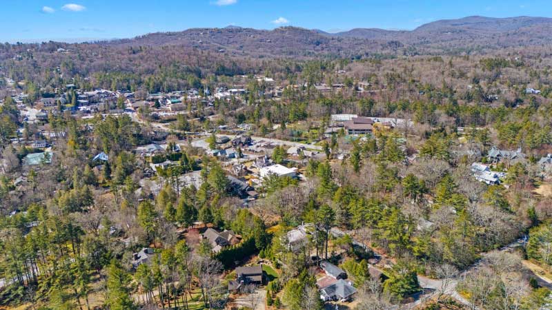
Highlands is a small mountain town with a big reputation. About 1,000 people live here year-round, yet the town fills its restaurants, trails and theaters every summer and fall. This page covers the basics a first-time visitor needs: where Highlands sits, what the weather does, how the town is laid out, how long to stay, and where to start.
Where Highlands is
Highlands sits on a plateau in the far southwest corner of North Carolina, inside the Nantahala National Forest and close to both the Georgia and South Carolina lines. Most of the town is in Macon County, with a small slice in Jackson County. The official average elevation within town limits is 4,118 feet, and the town straddles the Eastern Continental Divide.
Two businessmen founded Highlands in 1875. They drew a line from Chicago to Savannah and another from New Orleans to New York, and bet that the crossing point would become a trading hub. It grew into a resort town instead. By the 1930s, Atlanta golfer Bobby Jones and friends had founded the Highlands Country Club, and summer visitors have come for the cool air ever since.
Three state and federal roads meet downtown. US 64 runs west to Franklin through the Cullasaja Gorge and east to Cashiers. NC 28 runs north to Franklin and south toward Walhalla, South Carolina. NC 106 runs southwest to Dillard, Georgia. Asheville is about an hour and a half away, Greenville about two hours and Atlanta about two and a half. See Getting to Highlands for routes and airports.
Weather and what to pack
The elevation keeps summers mild. Highs average in the mid to upper 70s in July, and nights drop into the 50s. Winters are cold for the South, with January highs in the low 40s and lows in the 20s. Highlands also gets close to 90 inches of rain a year, so expect showers in any month. Average snowfall is around 10 inches.
| Month | Average high | Average low |
|---|---|---|
| January | 42°F | 24°F |
| April | 62°F | 39°F |
| July | 78°F | 58°F |
| October | 63°F | 41°F |
NOAA 1991-2020 normals. Pack for a ten to twenty degree swing between afternoon and evening.
- A rain shell in every season, plus a fleece or sweater even in July.
- Shoes with real tread. Rock around waterfalls and on summits stays wet and slick.
- Layers for fall. October mornings can be near freezing, with sunny 60s by afternoon.
- One nicer outfit for a dinner out or a show at the Performing Arts Center.
How the town is laid out
Downtown is compact. Main Street is the spine, lined with shops, galleries, restaurants and inns. Parallel and cross streets, including Spring Street, Oak Street, Fourth Street and Carolina Way, hold more shops and most of the parking. The Highlands Welcome Center sits at 108 Main Street, at the corner of First and Main, with maps, brochures and staff who know the area.
From Main Street, the town spreads into quiet residential blocks. Walk east and Main becomes Horse Cove Road, which leads to the Highlands Biological Station, the free Highlands Botanical Garden and the trail to Sunset Rock. To the north along Fourth Street are the Highlands Recreation Park, the Historic Village and the Highlands Performing Arts Center. To the west on Franklin Road is The Bascom, the town’s visual arts center.
Parking, walking and cell service
Highlands is very walkable once you are here. Sidewalks connect Main Street to the parks, the Botanical Garden and the 10-plus-mile Highlands Plateau Greenway, whose trailhead is on Oak Street between Second and Third. On summer and October weekends, downtown parking fills by late morning. Park on Spring Street, Fourth Street or Carolina Way and walk, or leave the car where you are staying. The Welcome Center asks visitors to use the top parking lot. Public EV chargers are on Oak Street, Third Street and at the Welcome Center.
A car is still essential for waterfalls, trailheads and Cashiers. Coverage is generally workable in town, but it drops on mountain roads, in the Cullasaja Gorge and on many trails. Download offline maps before you leave the house.
How many days you need
- Two days covers Main Street, Sunset Rock, a short waterfall loop (Bridal Veil and Dry Falls) and a couple of good dinners.
- Three to four days adds Whiteside Mountain, Glen Falls, The Bascom, a show at the Performing Arts Center and an afternoon in Cashiers.
- A week leaves room for Whitewater Falls, Lake Glenville, a fly-fishing trip, a rafting day near the Nantahala Outdoor Center and a few slow mornings. This is the right length for family reunions and big groups.
Highlands vs. Cashiers
Cashiers is the next community east on US 64, about 25 minutes away. People often say “Highlands-Cashiers” as if it were one place, and the two share a hospital, a chamber music festival and a lot of the same trails. They feel different on the ground.
| Highlands | Cashiers | |
|---|---|---|
| Type | Incorporated town with a walkable downtown | Unincorporated village around a crossroads |
| Elevation | About 4,118 ft | About 3,484 ft |
| Center | Main Street shops and restaurants | The Village Green park at US 64 and NC 107 |
| Best for | Dining, galleries, theater, walking | Lake Glenville, Whitewater Falls, Panthertown, the large grocery store |
Most visitors base in one and day-trip to the other. Read the Cashiers and Sapphire Valley guide before you go.
Where to begin
Start at the Welcome Center for a paper map, then walk up to Sunset Rock in the late afternoon for the view over town. From there, use these guides to plan the rest:
- 30 best things to do in Highlands
- The best time to visit, month by month
- Waterfalls near Highlands and scenic drives
- The best hikes, from Sunset Rock to Whiteside Mountain
- Lakes, fly fishing and family adventures
- Where to eat and groceries, private chefs and catering
- Arts and culture
- Fall foliage, Christmas, winter and events by month
- Day trips from Highlands
- Getting here and planning a group trip
If you are bringing a crowd, Fairview House sleeps 22 four blocks from Main Street, so the whole group can walk to town together.
Common questions
What is the elevation of Highlands, NC?
The official average elevation within town limits is 4,118 feet. Nearby summits are higher: Satulah Mountain reaches 4,543 feet and Whiteside Mountain 4,930 feet.
Is Highlands, NC walkable?
Yes. Downtown is compact, and sidewalks and the Highlands Plateau Greenway connect Main Street to parks, the Botanical Garden and Sunset Rock. You will still want a car for waterfalls and trailheads.
How many days do you need in Highlands?
Two days covers the highlights in town and a few waterfalls. Three to four days lets you add Whiteside Mountain, Cashiers and a show, and a week suits family reunions and large groups.
What is the difference between Highlands and Cashiers?
Highlands is an incorporated town at about 4,118 feet with a walkable Main Street. Cashiers is an unincorporated village about 25 minutes east, centered on the crossroads of US 64 and NC 107.
Does it snow in Highlands, NC?
Yes. Average snowfall is around 10 inches a year, and January lows average in the mid 20s. Shaded curves can stay icy after a storm.
Sources, checked October 2026
- Highlands, North Carolina (Wikipedia, NOAA climate normals)
- Highlands Chamber of Commerce: Contact / Welcome Center
- Highlands Chamber: Frequently Asked Questions
- Highlands Chamber: Getting Here
- Highlands Chamber: Main Street shopping
- Highlands Chamber Trails Brochure (2025)
- Cashiers, North Carolina, Wikipedia
- Cashiers Area Chamber: Local Info
- Highlands Biological Station
- The Bascom: A Center for the Visual Arts